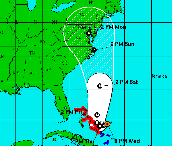
The latest forecast tracking from the National Hurricane Center shows Hurricane Joaquin making landfall south of New Jersey, near the northern border of North Carolina, Virginia Beach and Chesapeake Bay, then continuing on a slow north-westerly track.
The “cone of uncertainty,” as it has come to be known, has widened, and still includes New Jersey or even a potential track out to sea, though the official forecast track has shifted southwest compared to a forecast earlier Wednesday that indicated it would directly impact New Jersey.
“A significant adjustment to the forecast has been made this afternoon, and this shows an increased threat to the mid-Atlantic states and the Carolinas,” the National Hurricane Center said in a forecast discussion. “However, confidence in the details of the forecast after 72 hours remains low, since we have one normally excellent model that keeps Joaquin far away from the United States east coast. The range of possible outcomes is still large, and includes the possibility of a major hurricane landfall in the Carolinas.”
|
|
The storm had strengthened to pack winds of 115 m.p.h. by early Thursday morning.
In order to gather more data to feed to forecast modeling computers, the hurricane said a jet has been sent toward the storm to deploy weather balloons.
“Because landfall, if it occurs, is still more than three days away, it is too early to talk about specific wind, rain, or surge impacts from Joaquin in the United States,” the forecast said. “Even if Joaquin stays well out to sea, strong onshore winds will create minor to moderate coastal flooding along the coasts of the mid-Atlantic and northeastern states through the weekend.”
A hurricane watch for a portion of the U.S. coast could be required as early as Thursday evening, the hurricane center said.
Barrier island communities across New Jersey began preparing for the storm Wednesday. A marine forecast indicated seas of 18 to 23 feet offshore this weekend, a testament to the storm’s potential strength.

Advertisement

Police, Fire & Courts
South Toms River Man Charged in Violent Murder of Wife

Police, Fire & Courts
Toms River Man, 36, Charged With Failing to Register Under Megan’s Law


