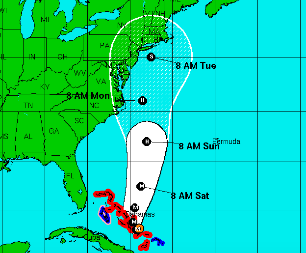
National Hurricane Center forecast, 11am, Oct. 1, 2015 (Credit: NHC)
Forecasts released Thursday show Hurricane Joaquin passing farther and farther offshore from New Jersey, trending toward an easterly track that would allow the Garden State to avoid a direct landfall of the storm, though predictions remain fluid and even an offshore pass could spell flooding and torrential rain for coastal area.
An update released at 11 a.m. by the National Hurricane Center shows Joaquin passing the central New Jersey coast around 8 a.m. Tuesday. The storm would then continue on a path toward New England. The easterly track differs significantly from changes made to the official forecast on Wednesday, which brought the storm further west. According to the current forecast track, Joaquin would pass off the coast of New Jersey as a strong tropical storm with winds of 70 m.p.h., just shy of hurricane strength.
At 11 a.m. Thursday, Joaquin was packing 125 m.p.h. winds and was located about 80 miles south-southeast of San Salvador.
|
|
“Confidence in the details of the forecast after 72 hours is still low, since there have been some large changes in the model guidance overnight and a large spread in the model solutions remains, with potential impacts from the Carolinas through New England,” the National Hurricane Center said in a forecast discussion. “It is also possible that Joaquin will remain far from the U.S. east coast.”
A hurricane watch for the U.S. coast would likely not occur until at least Friday morning.

Police, Fire & Courts
South Toms River Man Charged in Violent Murder of Wife

Police, Fire & Courts
Toms River Man, 36, Charged With Failing to Register Under Megan’s Law


