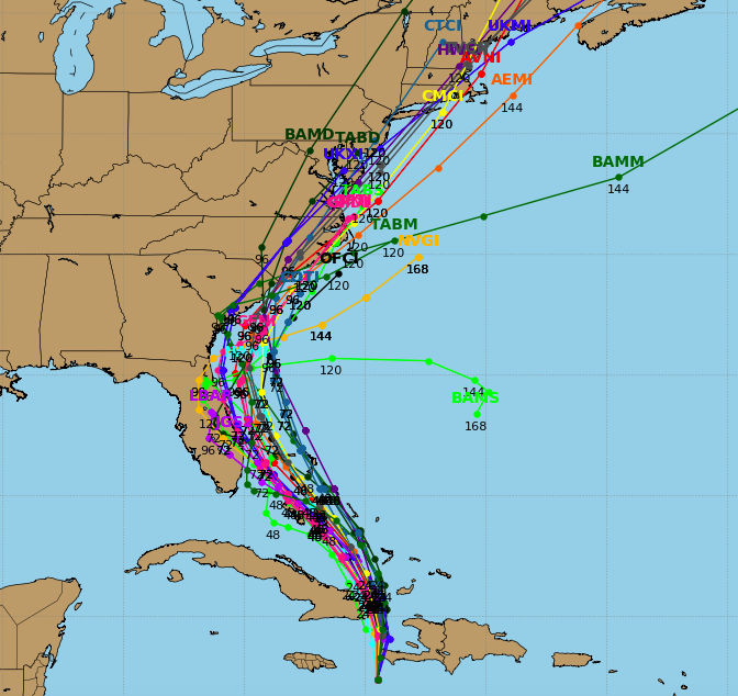
Hurricane forecasts are notoriously tricky, and can often change drastically in a matter of hours, but Shore residents began paying closer attention to Hurricane Matthew during the day Monday and overnight Tuesday as forecasting models suggested the storm could move close to New Jersey by this Sunday or Monday.
Matthew is currently located near Haiti, with a forecast track predicting the storm will travel up the Florida coast as a major hurricane on Thursday and Friday. The storm is now packing winds of 145 m.p.h. The official track from the National Hurricane Center, which extends five days, shows the storm traveling up the eastern seaboard, making landfall in southern North Carolina on Saturday before jutting back out to see and hovering off the New Jersey coast.
Officials in Florida and North Carolina have already declared states of emergency.
|
|
Reconcile yourself to the reality that Hurricane #Matthew may impact the East Coast. Embrace the uncertainty, don't fight it.
— Gary Szatkowski (@GarySzatkowski) October 3, 2016
“Deal with that uncertainty about Matthew threat by having a trusted weather source and by having a hurricane plan for your home/business,” Gary Szatkowski, the now-retired former chief meteorologist for the National Weather Service’s office in Mount Holly, tweeted Monday night. “Reconcile yourself to the reality that Hurricane Matthew may impact the East Coast. Embrace the uncertainty, don’t fight it.”
Szatkowski called on New Jersey residents to speak with family and friends about hurricane plans should the storm impact the state.
Dan Skeldon, a meteorologist for The Press of Atlantic City, said forecast models have provided a few different options for the storm – including several which would take it out to sea – though the models began shifting closer to the coast Monday night.
“An increasing number of models today shifted the track closer to the East Coast, which would obviously increase the impacts,” Skeldon wrote. “The advice for South Jersey residents remains the same: monitor future forecasts until the outcome becomes more certain. Impacts from Matthew, however major or minor they are, would not arrive until the weekend.”

Advertisement

Police, Fire & Courts
Grand Jury Indicts Point Pleasant Man, Once a Fugitive, for Attempted Murder


