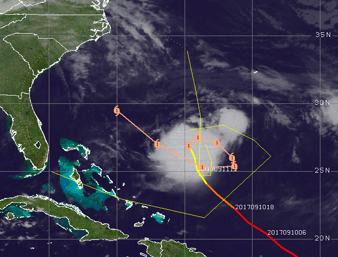
Hurricane Jose is now expected to make a full and complete circle, ultimately redirecting its movement toward the west and closer to the U.S. east coast.
While too early to tell whether the storm will move close enough to shore to either brush the coast or make landfall, the latest track from the National Hurricane Center positions the storm well off the Florida-Georgia border by Saturday, with the storm moving in a northwest motion. The loop back toward the coast comes after Jose is expected to travel southwest – essentially backwards – and then move closer to shore.
“Even with such a complex track expected to evolve, there is good agreement amongst most of the model guidance,” the National Hurricane Center said in a forecast discussion.
|
|
Forecast models agree the storm will turn toward the east coast of the United States, but longer term forecasts are less definitive. Potential tracks vary wildly, from landfalls in the south up to the Canadian maritimes, while others take Jose out to sea permanently.
“Until Jose is farther along on its loop, the models are likely to have large errors, and we should not take too much comfort (or indulge in too much angst) over a particular set of model runs,” the website Weather Underground reported.
Jose was packing 85 m.p.h. winds – a category one storm – and was expected to remain a category one storm when it inches closer to land.

Advertisement

Police, Fire & Courts
Man Who Stabbed Brick Woman 38 Times Near Park is Sentenced for Attempted Murder

Police, Fire & Courts
Driver Charged With DWI in Fatal Brick Accident; SUV Was In Wrong Lane of Route 70

Police, Fire & Courts
Police ID Victim, 58, in Fatal Brick Car Accident; Suspect Facing DWI Charge


