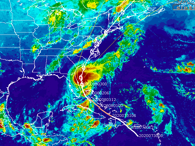
Tropical Storm Isaias will pound the Jersey Shore with flooding rainfall and dangerous winds, though it is unlikely to regain hurricane strength by the time it arrives Tuesday.
The National Weather Service issued a new advisory that continues the Tropical Storm Watch. In it, the forecast warned of sustained winds of 40 to 50 m.p.h. with gusts to 55 m.p.h. But there is also the potential for winds to reach up to 70 m.p.h. depending on the storm’s exact track and how long it remains over open water after an initial brush with the Outer Banks of North Carolina.
After a sunny day Monday, the first rain bands are predicted to move in overnight, the NWS said. A flash flood watch and high surf advisory has been issued from Monday night into Tuesday night. The storm will reach its peak in New Jersey in the evening hours on Tuesday, bringing several inches of rain to the Shore area as well as high winds and very heavy surf.
|
|
“Efforts to protect life and property should now be underway,” the NWS statement said. “Prepare for significant wind damage.”
If you have any preparation activities to complete, get them done during the day Monday. The heaviest rainfall and strongest winds will be moving into the region on Tuesday. If you need any last minute guidance on preparedness, go to https://t.co/VbU0lwzbHs
— Gary Szatkowski (@GarySzatkowski) August 2, 2020
The NWS is also predicting a storm surge of up to two feet from Tuesday morning to Wednesday morning, which will be combined with impacts from the recent full moon. Seas will run around 9-feet, building to 13-feet in the afternoon Tuesday. They will peak at about 17-feet Tuesday night.
The good news: Isaias is a quick mover. The track from the National Hurricane Center shows the storm rocketing up the east coast after its brush with New Jersey. By 8 a.m. Wednesday morning, it is forecast to be affecting Maine.


