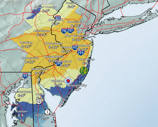
A winter storm watch has been upgraded to a winter storm warning for the Shore area, with the region forecast to receive between 7-13 inches of snow Sunday through Tuesday.
The exact amount of snow accumulation the potent nor’easter will bring is still in question, though meteorologists are increasingly confident that the storm will bring significant snow to the region, including the coast. The latest graphical analysis from the National Weather Service shows the Shore area on a thin line between 6-8 inches of snow and 8-12 inches of snow. The official warning statement calls for 7-13 inches. The watch runs from 1 p.m. Sunday to 10 a.m. Tuesday.
“Heavy snow [is] expected,” the statement said. “Total snow accumulations of 7 to 13 inches expected. Winds gusting as high as 45 mph.”
|
|
A coastal flood watch has also been issued, as the storm is coastal in nature and will bring high tides to the region.
The watch calls for 1-2 feet of inundation above ground level possible in low-lying areas near shorelines and tidal waterways.
“At this level, widespread roadway flooding occurs in coastal and bayside communities and along inland tidal waterways,” the watch statement said. “Many roads become impassable.”
The coastal flood watch is in effect from 7 a.m. Monday to 5 p.m. Tuesday.
Snow is expected to begin after 4 p.m. Sunday, according to the official NWS forecast. The high Sunday will reach 33 degrees. After 1-4 inches fall overnight, the precipitation is expected to turn to rain during the day Monday as the high will reach 38 degrees. The mix will turn back to snow late in the day Monday or Monday night, and continue as a mix (or all snow) Tuesday before 1 p.m., when the system is due to exit.

Advertisement
Brick Life
Try, Try Again

Police, Fire & Courts
Former Ocean County Teacher Sentenced to Parole for Relationship With Student


