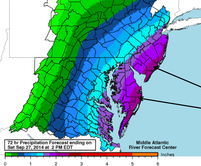
Rainfall amounts expected in a coastal storm hitting New Jersey Sept. 25, 2014. (Photo: National Weather Service)
The National Weather Service predicted two or more inches or rain would fall in coastal areas of New Jersey as a storm system moves through Wednesday night into Thursday.
The weather service’s office in Mount Holly released a briefing package late Wednesday afternoon warning the heaviest rain would come late Wednesday night into Thursday morning and would also bring strong winds to the area.
“Easterly winds will gust over 35 mph at times near the coast tonight and Thursday as they gradually turn to the northeast,” the forecast said. Wind gusts could reach close to 50 m.p.h. at times, forecasters said.
|
|
Minor tidal flooding is expected along the New Jersey coast during the times of high tide on Thursday, though heavy rain at the time of high tide could make flooding worse, the forecast said. Forecasters issued a coastal flood advisory until 12 noon Thursday, a warning to motorists that roads prone to tidal flooding may be closed to traffic.
In Brick, high tide at the Mantoloking Bridge will occur at 1:09 a.m. Thursday. At Beaver Dam Creek, high tide will occur at 11:21 a.m. and 11:30 p.m. Thursday.
Beach erosion is also a possibility with the storm. A gale warning was in effect as well as a small craft advisory. The National Weather Service was predicting seas will reach 8 to 11 feet overnight and during the day Wednesday. The storm was also expected to cause rough surf and dangerous rip currents.


Police, Fire & Courts
Teacher From Brick, 36, Charged With Carrying on Affair With Student

Brick Life
Adult Autism Transition
Police, Fire & Courts
Teacher From Brick Charged in Another Sex Affair With Student


