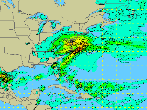
The GFS forecast model for Feb. 1-2. (NCAR)
Local meteorologists might be a bit gun-shy following a high profile busted forecast of a “blizzard that wasn’t” earlier this week, but behind the scenes, they are tracking another potential coastal storm that could dump snow, or rain, or next to nothing, on the Shore are Sunday night into Monday.
Nick Pittman, a meteorologist who runs the South Jersey News 24 website, said the forecast is still up in the air.
“I think something will affect us, but I’m leaning towards my original thoughts earlier though, a snow/rain/snow event, but we shall see,” he posted via social media early Wednesday morning.
|
|
The GFS, a forecast model that was historically known as being inaccurate – but nailed the forecast on this week’s storm after receiving a major software update earlier this week – is predicting a potent snow event for the Shore area Sunday night into Monday. But most meteorologists agree that it’s far too early to tell what will happen, especially since just one model run predicted snow.
Pittman said Sunday threat depends on where a storm currently in the western U.S. goes – cutting through the Ohio valley, bringing the Shore warm air, and then rain; or heading to see and developing into a coastal storm with cold air behind it, raising the odds of a snowstorm.
Dan Skeldon, a meteorologist for The Press of Atlantic City, said the same model that predicted a snowstorm during a forecast run last night predicted just some cold, light snow earlier in the day.
“We’re coming off a major storm(or lack thereof) with poor model performance, and we’re 3-4 days away from this storm,” said Skeldon, also in a social media post. “”et’s give it a day or two and see how the pattern sets up.”
Gary Szatkowski, meteorologist in charge at the National Weather Service’s office in Mount Holly, likewise took to social media to talk about the potential for a snowy Sunday evening.
“Right now [NWS] forecast suggests mainly snow,” he tweeted. But, he said, most of the relevant data won’t be in until Thursday night, so any forecasts made now are up in the air.


Police, Fire & Courts
Teacher From Brick, 36, Charged With Carrying on Affair With Student

Brick Life
Adult Autism Transition
Police, Fire & Courts
Teacher From Brick Charged in Another Sex Affair With Student


