Credit: NWS (Click to Enlarge)
Forecasters are beginning to concede that the current nor’easter could be a blizzard that wasn’t. The National Weather Service scaled back its forecast snow totals for Ocean County in an unusual early-morning update Tuesday.
“My deepest apologies to many key decision makers and so many members of the general public,” said Gary Szatkowski, meteorologist in charge at the NWS’s Mount Holly office, issuing a public apology over Twitter.
The nor’easter formed as forecasters predicted it would – only 90 miles farther east than expected, leading to a surprise among meteorologists who predicted as much as three feet of snow would fall along the Jersey Shore.
|
|
“You made a lot of tough decisions expecting us to get it right, and we didn’t,” Szatkowski said.
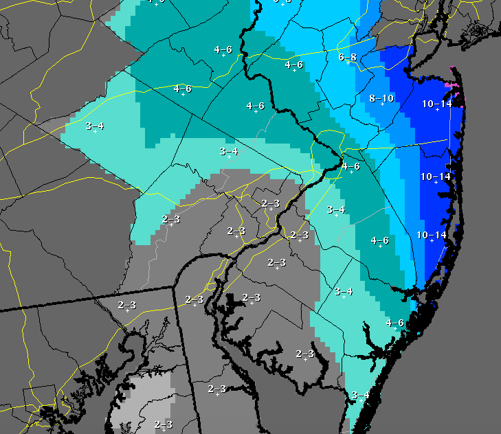
Brick Township – and the rest of eastern Ocean County – was now on track to receive between 10 and 14 inches of snow before the system completely moves out of the region by 3 p.m. Tuesday. The NWS’s forecast calls for 4-8 inches of snow to fall overnight and potentially 3-5 more inches to fall during the day Tuesday. Winds will continue to gust as high as 43 m.p.h. Tuesday.
So, why did the storm appear so much farther away from the Shore than expected? Meteorologists are pointing to what is known as an “inverted trough” that formed in Pennsylvania during the day Monday – essentially, an uplift of air – which kept the storm farther out to sea. The trough’s development was not noted in previous forecasting models.


Police, Fire & Courts
Teacher From Brick, 36, Charged With Carrying on Affair With Student

Brick Life
Adult Autism Transition
Police, Fire & Courts
Teacher From Brick Charged in Another Sex Affair With Student


