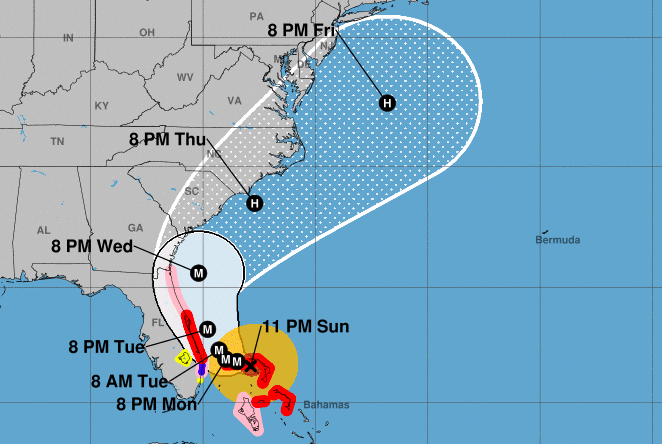
Hurricane Dorian’s forecast track, Sept. 2, 2019. (Credit: National Hurricane Center)
As residents of coastal cities in Florida up through the Carolinas are bracing for the potential impacts of the category-five Hurricane Dorian, the Jersey Shore was keeping a cautious watch on its future track.
The National Hurricane Center, for the first time, forecast that the storm would move toward New Jersey – but whether it will hug the coast or be so far offshore that impacts will be minimal is unknown. The track of the storm is so uncertain that it is even difficult for meteorologists to determine the impact Florida will see from Dorian within the next 48 hours.
The NHC’s forecast early Monday morning showed the storm positioned somewhere off New Jersey this Friday and Saturday, but while the “cone of uncertainty,” as it has colloquially become known, shows the Shore possibly being brushed by the storm, it is more likely that it will be headed out to sea by the time the weekend rolls around.
|
|
Dorian will still be packing winds of 85 m.p.h. – category one hurricane strength – by the time it moves northward. As it currently stands, the National Weather Service is forecasting a chance of showers on Friday followed by sunny skies Saturday. That could change, but for now the impacts most likely for the Shore ares will be rough surf, a strong breeze and the potential for tides to run higher than normal.
Also, by the time it’s off the New Jersey coast, the storm will have significantly weakened, according to the National Hurricane Center.
“The models show an increase in shear when Dorian tracks near Georgia and the Carolinas, which should cause more notable weakening,” a forecast discussion statement said.
As for comparisons for Superstorm Sandy, which devastated the region in 2012, one influential forecaster dismissed any perceived parallels.
“Sandy came into NJ at a perpendicular orientation, worst possible landfall for the region,” Meteorologist Steve DiMartino of NY-NJ-PA Weather wrote via social media. “Irene slowed to a crawl to produce widespread intense rainfall. Both are nothing like this situation.”


Police, Fire & Courts
Teacher From Brick, 36, Charged With Carrying on Affair With Student

Brick Life
Adult Autism Transition
Police, Fire & Courts
Teacher From Brick Charged in Another Sex Affair With Student


