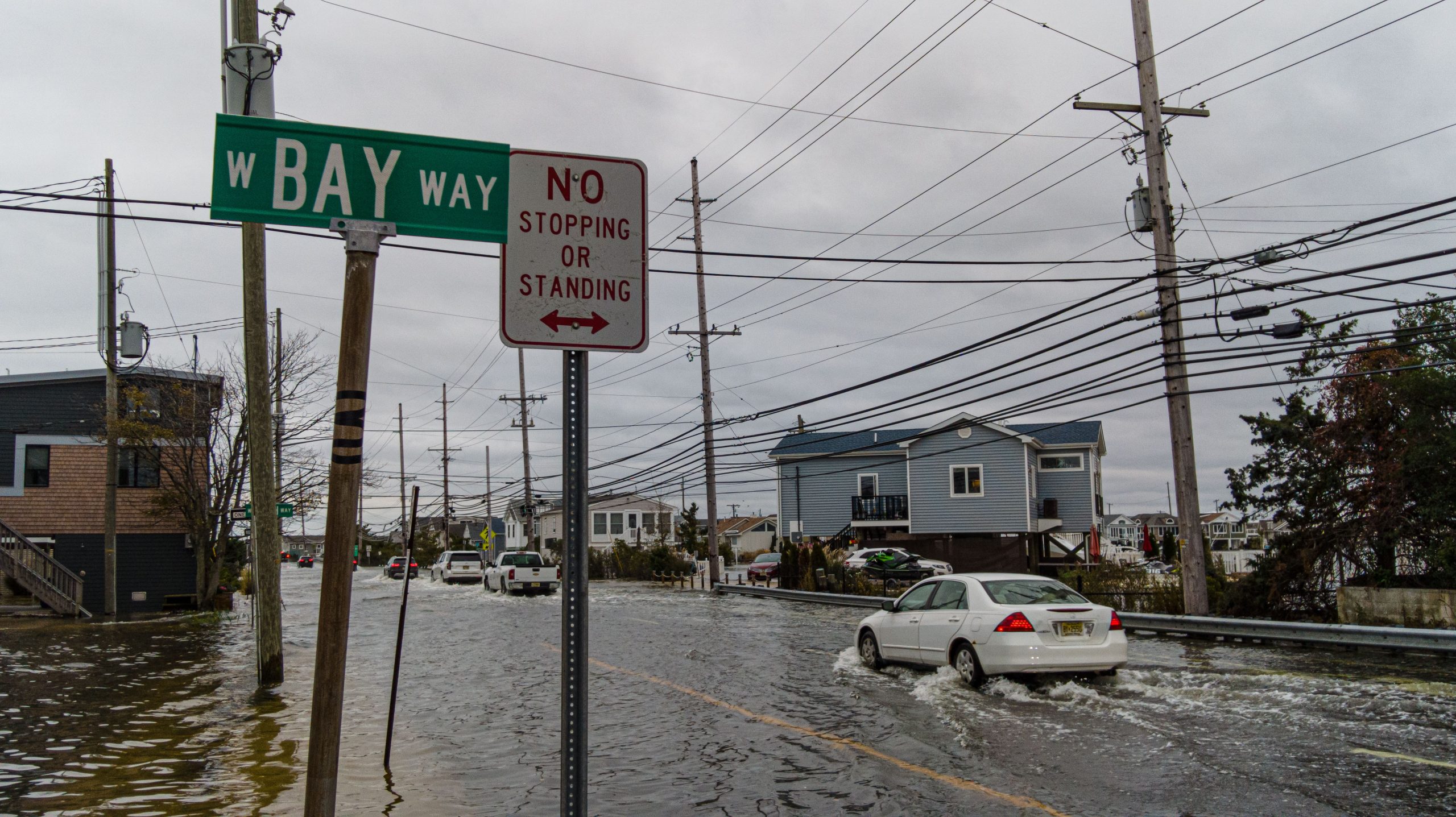
Floodwater began building during the rising afternoon tide Thursday, catching some drivers by surprise and sending residents in low-lying areas scurrying to move cars out of harm’s way.
The flooding began to occur between two to three hours before high tide on Barnegat Bay, which occurred at 6:10 p.m. The worst-affected areas on the island were Normandy Beach, Chadwick Beach and the Ocean Beaches. In that portion of the island, the water reached about two feet deep on Route 35. Some streets were closed by police.
In Normandy Beach, Brick Township police were deployed in Humvees to control traffic and assist in emergencies. Police in Bay Head closed Bridge Avenue, which was inundated with more than a foot of water in some areas.

Flooding on Ocean County’s northern barrier island, Oct. 28, 2021. (Photo: Daniel Nee)
|
|

Flooding on Ocean County’s northern barrier island, Oct. 28, 2021. (Photo: Daniel Nee)
Flooding on Ocean County’s northern barrier island, Oct. 28, 2021. (Photo: Daniel Nee)
On the mainland, there was significant flooding on Princeton Avenue in Brick, leading police to shut down portions of that roadway. In Toms River, authorities put out a general alert stating that many roads “throughout town” were impacted and drivers should not attempt to motor through flooded streets as the depth of the water can be deceiving – especially at night.
“The high tide of biggest concern is on Friday, but tidal flooding is also possible with Thursday high tides and it may continue into Saturday,” the National Weather Service said in a statement.
According to the NWS report, the flooding will continue through several high tide cycles as the second coastal storm of the week approaches the region. A briefing package released by the NWS’s Mount Holly office forecast gale force wind gusts and rough seas Friday, with “widespread minor and some moderate tidal flooding.”

Flooding on Ocean County’s northern barrier island, Oct. 28, 2021. (Photo: Daniel Nee)

Flooding on Ocean County’s northern barrier island, Oct. 28, 2021. (Photo: Daniel Nee)
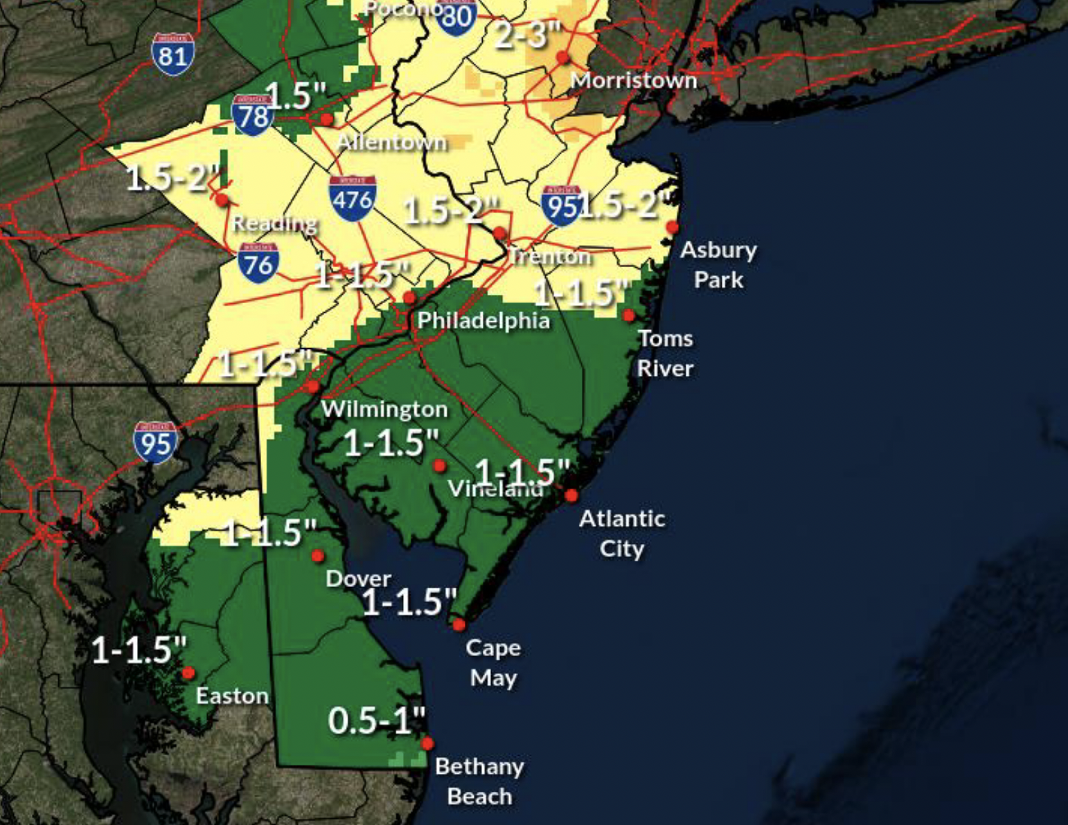
NWS predictions for the Oct. 29-30, 2021 storm. (Credit: NWS)
“Wind gusts 45 to 50 mph may result in tree and wire damage,” the NWS statement warned, though the highest winds were forecast for the southernmost portions of New Jersey and could be somewhat less damaging locally.
Meanwhile, another 1-2 inches of rain is forecast to fall on the region Friday and Friday night. Locally higher amounts of 2 to 4 inches are possible.
An east wind is anticipated to increase to 15 to 30 MPH on Friday with gusts of 30 to 45 MPH possible by evening. The strongest wind and gusts should occur Friday afternoon and evening with speeds diminishing late on Friday night.


Police, Fire & Courts
Teacher From Brick, 36, Charged With Carrying on Affair With Student

Brick Life
Adult Autism Transition
Police, Fire & Courts
Teacher From Brick Charged in Another Sex Affair With Student


